----
What is the land access layer?
The land access layer is a map overlay that shows public and protected land across the United States, colour-coded by access type. It helps hikers quickly understand where they can go, what restrictions apply, and whether fees or permits are required before they set out.
Where does this data come from?
The layer is built from the USGS Protected Areas Database of the United States (PAD-US 4.1), the most comprehensive inventory of protected land in the country. We enrich it with data from the National Park Service API, Recreation.gov, the U.S. Forest Service, and the Bureau of Land Management to fill in details like fees, permits, and seasonal opening dates.
How often is the data updated?
We aim to refresh the dataset quarterly. The date shown in the "last updated" field on each area reflects when our pipeline last processed the data. PAD-US itself is typically updated annually by the USGS.
What do the access categories mean?
Open Access — Free, unrestricted public access with no known barriers to entry.
Entry Fee — An entrance or parking fee is required. The fee amount is shown where known.
Permit Required — You need an advance permit, reservation, or booking before visiting. A link to the permit source is provided where available.
Limited Access — Trails or access routes exist, but conditions apply. This may include seasonal restrictions, zonal closures, or managed access programs. Check the area details for specifics.
Restricted — Access is significantly limited. Entry may require special authorisation, guided tours, or be confined to specific areas or times.
Closed — No public access is permitted. This includes military installations, critical habitat preserves, and permanently closed areas.
Unknown — Access status could not be determined from available data. Treat these areas with caution and verify locally before visiting.
Why does an area show a different access type than I expected?
Our access classifications are derived from the GAP Status codes in the PAD-US dataset, supplemented by NPS, USFS, BLM, and Recreation.gov data. There are several reasons a classification might not match your experience on the ground.
Data lag. Access rules change — a park may introduce or drop a fee, a seasonal closure may shift dates, or a new permit system may be introduced. Our data reflects the most recent PAD-US release and API queries, but real-world changes can outpace the update cycle.
Boundary precision. The boundaries shown are derived from federal and state GIS datasets. They are accurate at a planning level but should not be used for precise legal boundary determination. In some cases, boundaries may appear to overlap with private land or neighbouring jurisdictions due to mapping generalisation.
Overlapping designations. A single piece of land can have multiple designations in PAD-US — for example, a national forest may contain a designated wilderness area with stricter access rules. Where designations overlap, we prioritise the more restrictive classification so you're aware of potential limitations.
Seasonal variation. Some areas are marked as seasonal because their access changes throughout the year (e.g. snow closures, wildlife nesting seasons). The open/close dates shown are approximate and based on the most recently available data. Always confirm current conditions with the managing agency.
Hunting areas. Areas identified as hunting or game lands are flagged with an orange overlay. Hunting seasons, species, and regulations vary by state and zone. This layer does not replace state wildlife agency guidance.
Why are some areas missing?
PAD-US is the most complete dataset available, but it does not cover every piece of accessible land in the country. Private land trusts, informal access agreements, county parks not yet reported to USGS, and tribal lands with public access programs may not appear. We're working to improve coverage over time.
Can I rely on this for navigation or legal boundary information?
No. This layer is an informational planning tool, not a legal survey. Boundaries are approximate. Always verify access permissions, current conditions, and property boundaries with the local land management agency before your visit. Trespassing on private or restricted land is a legal offence regardless of what any map shows.
I think the data is wrong for a specific area. What should I do?
We appreciate corrections. If you notice an area where the access type, boundary, or details seem incorrect, please contact us at [email protected] with the area name and what you believe is inaccurate. We'll investigate and update the data in our next refresh cycle.
What does GAP Status mean?
GAP Status is a conservation measure assigned by the USGS that indicates the level of protection a piece of land receives. It ranges from 1 (highest protection, managed for biodiversity) to 4 (no known mandate for protection). We translate GAP Status into our hiker-friendly access categories, but the original GAP code is available in the area detail view for anyone who wants it.
Does this cover land outside the United States?
Not currently. The land access layer covers the 50 US states and the District of Columbia. We're exploring options for expanding to other countries in the future.
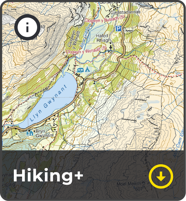
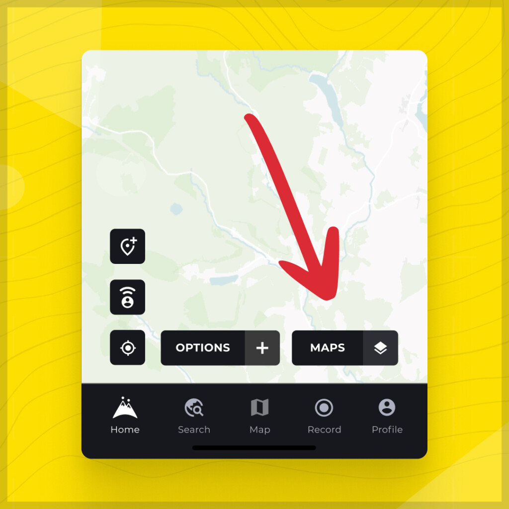 Here you will find our base maps, Standard and Satellite as well as our map collections, Hiking+, National+ and Historical+.
Harvey maps is located in the Hiking+ map collection. Tap the cell to activate it!
Here you will find our base maps, Standard and Satellite as well as our map collections, Hiking+, National+ and Historical+.
Harvey maps is located in the Hiking+ map collection. Tap the cell to activate it!
 Now move the map over to the UK, where you will see our coverage coverage areas. Zoom into these area to reveal the stunning Harvey Maps!
Easy!
Now move the map over to the UK, where you will see our coverage coverage areas. Zoom into these area to reveal the stunning Harvey Maps!
Easy!