

💻 Looking to do this on the HiiKER website? See Printing maps from the HiiKER website.
You can create printable PDF maps in HiiKER as a physical backup for your hikes — a real map that never runs out of battery.
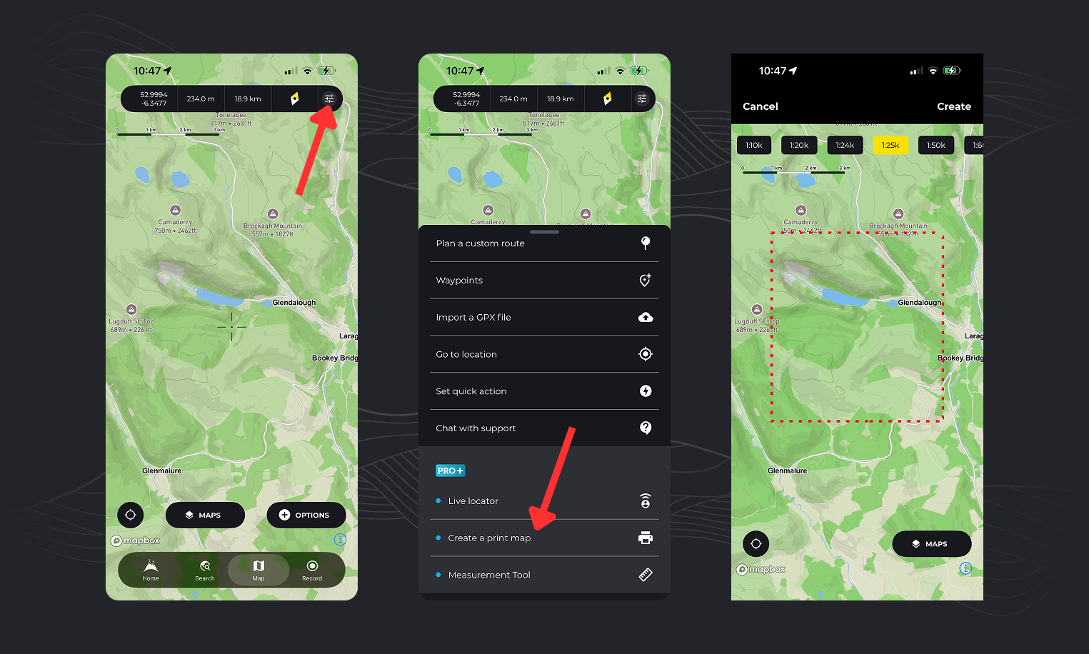
There are 2 ways to print maps from the app
Print an area of the map
- Open the Map tab
- Tap the Options button
- Select “Create a Print Map”
- Choose your preferred scale at the top of the screen
- Move and zoom the map to position the red dashed rectangle over the area you want to print
- Tap “Create”
- Give your print map a name
Your map will begin processing and will be available shortly in your print maps list.

Print a hike map
- Open the hike you want to print (this can be a HiiKER hike or any planned or recorded trail)
- On the overview page, tap “More” and select “Print Map”
- If it’s a multi-day hike, choose the day or route you want to print
- The map will load in the print selector, where you can choose your scale
- Move and zoom the map to position the red dashed rectangle over the area you want to print (you can create multiple print maps for longer trails)
- Tap “Create”
- Give your print map a name
- Your map will begin processing and will be available shortly (you can refresh the print maps list to check progress)
Print settings
Open the settings sheet on the print screen to change how the sheet is laid out. Everything below can be set in the app.
What to print
- Whole route — HiiKER fits a scale to the whole walk and lays it out over as many sheets as that takes. There’s no scale slider in this mode, because the scale is chosen for you.
- This map area — prints the rectangle you framed on the map, at the scale you picked. This is the default when you start from the Map tab, since there’s no route to fit.
Page size and orientation
Choose A5, A4, A3 or Letter, in portrait or landscape. A4 portrait is the default. Changing the page size or orientation reshapes the print rectangle, so the map re-fits to show you the new shape.
Scale
The scale picker offers 1:10k, 1:25k, 1:50k, 1:100k and 1:250k, with 1:25k as the default. Sheets are rendered at 300 DPI.
Scale controls how much ground fits on the page — it is not the same thing as which mapping is drawn. A 1:50k sheet printed from National+ is not necessarily the 1:50,000 map series.
Grid and projection
Pick the projection the sheet is gridded and aligned to:
- Mercator — latitude and longitude (the default)
- OSGB — the British National Grid
- Irish Grid
- NZMG — New Zealand Map Grid
- UTM — the zone is taken from your location
Choosing a national grid rotates the sheet to grid north, so the kilometre lattice sits square to the paper the way it does on a printed OS sheet. The projections use the same definitions as the app’s own grid reference readout, so the two can’t disagree. The projected grids are only offered where they’re valid — OSGB won’t be an option for a walk in the Alps.
What appears on the sheet
- Grid — on by default. Turning it on adds a gutter around the map, so the map window is slightly smaller.
- Magnetic declination — on by default, for setting your compass.
- Scale bar — on by default.
- Legend — on by default.
- Sunrise and sunset times — on by default, paired with a hike date. Set the date or the times won’t print: sun times are calculated for a specific day, so a sheet with no date printed on it comes out without them.
Which maps can I print?
You can print: Standard, Satellite, National+, Historical+ and Parks.
You cannot print: Hiking+ and Lidar. Both are restricted by our licensing agreements.
The restriction on Hiking+ covers the whole collection — that includes Harvey Maps and EastWest Mapping. In the print map style picker these appear dimmed rather than hidden; tapping one shows a message explaining it can’t be printed. That’s expected behaviour, not a bug.
The same restriction applies on the HiiKER website.
Settings only available on the website
A few print options are on hiiker.app/print-maps but not yet in the app:
- Elevation profile on the sheet
- QR code linking back to the hike
- Information sheet printed alongside the map
- One sheet per day of a multi-day hike
💡 Top tip: your print maps sync across app and website, so you can build a sheet on your phone and print it from a desktop later.
While on the print selection screen, tap the “Maps” option and select the “National+” option.
Harvey Maps are part of the Hiking+ collection, which cannot be printed. As per our current licensing agreement with Harvey Maps, we cannot allow our users to print Harvey Maps directly from the app or website. If you want a printed version of a particular Harvey Map, we recommend supporting them by purchasing via their website: https://www.harveymaps.co.uk/
EastWest Mapping is part of the Hiking+ collection, which cannot be printed. As per our current licensing agreement with EastWest Mapping, we cannot allow our users to print EastWest Mapping directly from the app or website. If you want a printed version, we recommend supporting them by purchasing via their website: https://eastwestmapping.ie/
Lidar is excluded from printing for licensing reasons, the same as Hiking+. It appears dimmed in the print map style picker. For a printed sheet of the same ground, National+ or Standard are the closest alternatives.
While on the print selection screen, tap the “Maps” option and select the “Satellite” option.
While on the print selection screen, tap the “Maps” option and select the “National+” option.
While on the print selection screen, tap the “Maps” option and select the “National+” option.
A3 is available in the app: open the print settings sheet and choose A3 under page size. It’s also available on the HiiKER website.

Hi Pete, When I go to print the map which I have East west mapping layer on, it dosnt print the East west Map but just a generic one. I’m doing this on phone. Am I doing something wrong?
Thanks, James
Hi James. There’s currently no way to print EastWest mapping (or any premium mapping for that matter). We are working on this, but in the meantime, you can only print the standard OSM layer
Has there been any update to this so far in regards to printing premium maps? Also, I don’t see an option to print a map from the webpage only the app gives me the option.