

Looking to do this in the HiiKER app? See Plan a hike in the app.
The Hike Planner at hiiker.app/hike-planner is the most powerful way to plot a route — from a quick afternoon loop to a multi-week thru-hike. It’s built for desktop browsers, where a big screen and a mouse make route planning easy.
In this article: Plotting a route · Routing modes · Route tools · The right-click menu · Elevation profile · Saving your plan · Good to know
Plotting a route
- Open the planner from Plan a hike in the navigation bar, or from the map’s Options menu.
- Click the map where your hike starts, then keep clicking to add points — HiiKER routes between them along known paths.
- Drag the line to reshape it, or drag any control point to a new spot.
- Your running totals — distance, ascent and estimated time — update live under Total at the bottom of the left panel, with the Est. Difficulty beneath. Click the difficulty to set it yourself.
- Made a mistake? Use the undo and redo arrows at the top of the Actions panel.
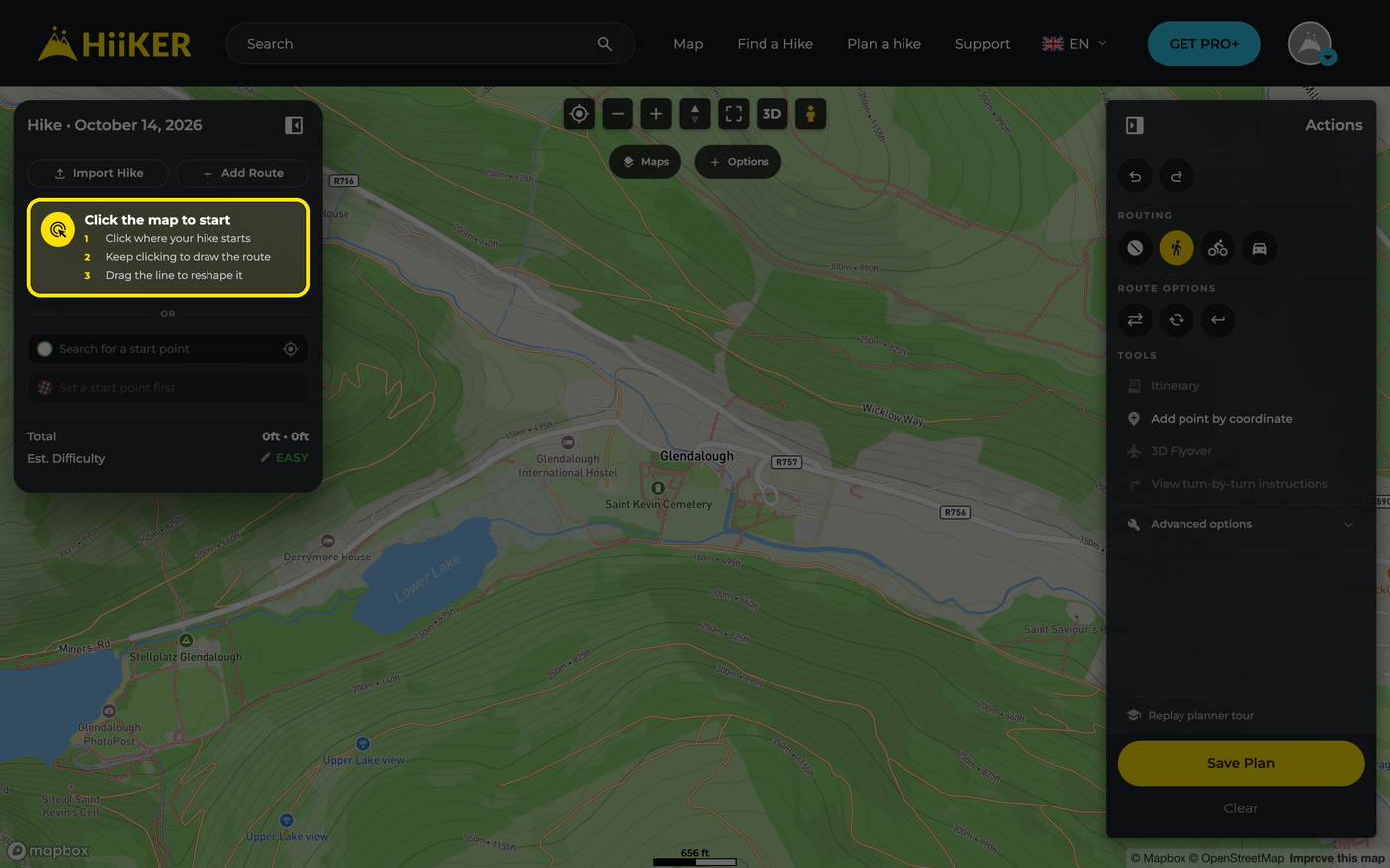

Prefer to type? On a new plan, use Search for a start point (or the location button beside it for where you are now), then Search for an end point — HiiKER plots the route between them. Once a route is drawn, its start and end show in the left panel: click + beside the end to continue the route to another place, or Add highlights to search for places along it.
The 1 day row at the top of the panel lets you split a long walk into days — see Planning a multi-day hike on the HiiKER website.
Routing modes
The Routing buttons in the Actions panel set how new points are joined (hover a button to see its name):
- Draw straight lines — no snapping, for going off-path.
- Snap to hiking paths — the default.
- Snap to bike routes — cycle routes.
- Snap to roads — handy for transport legs.

Route tools
Under Route options in the Actions panel:
- Reverse — swap the start and end.
- Loop — close the route back to where you started.
- Out and Back — return the way you came.
Under Tools:
- Itinerary — a printable summary of the whole trip.
- Add point by coordinate — drop a control point at an exact Lat/Long, UK Grid Reference or Irish Grid Reference.
- 3D Flyover — preview your route as a 3D fly-through.
- View turn-by-turn instructions — every turn on the selected route, as the HiiKER app will announce it. It’s greyed out when a route has no turn data, such as straight lines you’ve drawn or a route you’ve imported.
Click Advanced options for the rest:
- Add trace — load a GPX, KML or GeoJSON file as a guide line you can trace your route over.
- Add control points — add evenly spaced control points along the route.
- Merge all routes — join all your main routes into one, on a single day.
- Manage control points — remove them all, or select an area and delete just the points inside it.

The right-click menu
Right-click the map for quick actions. What you see depends on where you click:
- Anywhere — Show Coordinates and Add Hike Highlight.
- On your route — Add to route (extend the route from its last point to that spot) and Add intermediate control point (add a point there to reshape that stretch).
- On a point of interest — Add to route and Add POI as Hike Highlight.
- On a control point — Split Route Here (the rest of the route becomes the next day), Add turn-by-turn prompt and Remove control point.
- On another route in your plan — Activate Route to edit it.

The elevation profile
The chart at the bottom shows the elevation along your route, with its distance, ascent and descent, the high point marked, and sunrise and sunset for the day. Move your mouse along it to see distance, height, gradient and (where we know it) the path surface at any point — a marker follows on the map. Click the chart to add a control point at that spot, or use the arrow on its left to fold it away.

Saving your plan
When you’re happy with the route, click the yellow Save Plan button — you’ll need a free HiiKER account. Clear, just below it, empties the planner so you can start again. See Saving and sharing your planned hikes for the save options.

Good to know
- Not ready to save? Your work stays in this browser. Next time you open the planner it asks “You have unsaved changes. Do you want to load them?”
- Keyboard shortcuts: Ctrl+Z to undo and Ctrl+Shift+Z to redo (Cmd on a Mac).
- The Maps button changes the map style. Options opens Waypoints, Go to location and Create print map (PRO+).
- Plot a single route over 30 km and the planner suggests splitting it into days, which makes it easier to follow on the trail.
- On a phone, hiiker.app shows an Open in app button instead of the planner — plan in the HiiKER app there.
Next steps: Planning a multi-day hike on the HiiKER website · Saving and sharing your planned hikes · Importing routes on the HiiKER website
